GEOLOGICAL DATA INSIGHTS
Geological Data Insights Using Scanning Technology
Veracio’s scanning technology provides high-resolution mineralogical, geochemical, and structural data, reducing manual logging effort and improving geological interpretation.
AI-driven structural logging and predictive models based on geochemical footprints offer a robust foundation for advanced orebody characterization.
Real-Time, High-Accuracy Geochemistry
Veracio’s advanced XRF scanning delivers real-time, non-destructive assays with precision, accuracy, and unmatched elemental range, enhancing geochemical logging and resource evaluation.
Mineralogy for Smarter Geological Models
Veracio’s integrated hyperspectral and XRF scanning delivers fast mineralogy and geochemistry data—reducing uncertainty and improving geological models.
High-Resolution Geological Photography for Accurate Analysis
Veracio’s high-resolution imaging system captures detailed visual data, enhancing geological interpretation and ensuring reliable analysis.
3D Topography & Bulk Density with Lidar
LiDAR scanning generates a precise point cloud of the core in its tray, enabling accurate volume and bulk density calculations for detailed geological modeling.
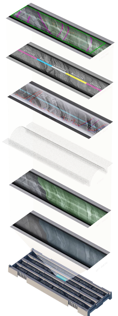
Multiple Data Streams in a Single Scan
Assistive Logging
Core scanning enables the simultaneous collection of aligned datasets—mineralogy, geochemistry, and imagery—ready for advanced analysis and statistical processing, including AI and machine learning.
These technologies are increasingly used in mining to enhance interpretation and extract greater value from geological data.
Geochemistry
Veracio’s advanced XRF scanning delivers precise, non-destructive multi-elemental assays, reducing dependence on lab analysis and minimizing data collection errors.
This improves geological model reliability, accelerates reconciliation, and saves time and resources.
Mineralogy
Veracio’s approach to VNIR and SWIR scanning delivers mineralogical results within 24 hours, reducing delays and improving decision-making.
Photography
An automated process that captures high resolution photos of both wet and dry core.
Controlled environments ensure that large-scale core processing campaigns are captured and recorded consistently, using the same standards and conditions.
Topography
Using Lidar scanning, a point cloud of the core within its core box is captured, recording its profile and topography for further analysis and to derive data such as volume and bulk density.
Automation
The handling, logging and capture of core is semi-automated, controlled and achieved in a highly-repeatable manner under the supervision of a single field technician.